VOGELER LAB
  • Home
  • Projects
  • Lab Members
  • Publications
  • Data Products
  • Contact

A bottom-up, stakeholder driven Carbon Monitoring System for regional biomass carbon dynamics: Phases I-III
March 2020

Project Summary

Picture
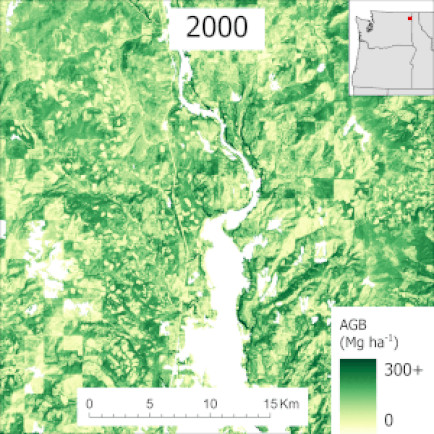
Accurately measuring forest carbon storage and flux is necessary for national carbon accounting programs and can improve our understanding of earth’s carbon cycle. As part of the NASA Carbon Monitoring Systems program, we’ve developed a method to integrate field data, multiple lidar collections, aerial imagery, and Landsat time series to provide estimates of forest and woodland aboveground biomass (AGB) across the western USA. Our workflow will yield annual AGB maps for the years 1985 – present at a 30-m spatial resolution. These maps are aggregated to the county-level and compared to AGB estimates calculated from independently collected Forest Inventory and Analysis (FIA) field measurements. In response to stakeholder feedback, we also will create annual maps of basal area, timber volume, and surface fuels. We will further analyze the Landsat time series to identify and map forest disturbances including harvest, fire, insects, and stress (e.g., drought), which will provide insight into disturbance trends and post-disturbance recovery.

Phase-II Research Objectives

Picture

Objective 1

Quantify and map above ground biomass carbon pools and fluxes across the western US 1984-2020 using a multi-tiered remote sensing approach.

​Objective 2

Recalibrate model-based forest carbon predictions leveraging the FIA forest inventory record, ICESat-2 and GEDI lidar using a model-assisted estimator.

Objective 3

Map additional management-relevant forest attributes across the western US to engage stakeholders.

Project Outputs

Publications
Mauro, F., Monleon, V. J., Gray, A. N., Kuegler, O., Temesgen, H., Hudak, A. T., Fekety, P. A., & Yang, Z. (2022). Comparison of Model-Assisted Endogenous Poststratification Methods for Estimation of Above-Ground Biomass Change in Oregon, USA. Remote Sensing, 14(23), Article 23. 
​
https://doi.org/10.3390/rs14236024

Mauro, F., Hudak, A. T., 
Fekety, P. A., Frank, B., Temesgen, H., Bell, D. M., Gregory, M. J., & McCarley, T. R. (2021). Regional Modeling of Forest Fuels and Structural Attributes Using Airborne Laser Scanning Data in Oregon. Remote Sensing, 13(2), 2. https://doi.org/10.3390/rs13020261 

Fekety, P. A., Crookston, N. L., Hudak, A. T., Filippelli, S. K., Vogeler, J. C., & Falkowski, M. J. (2020). Hundred year projected carbon loads and species compositions for four National Forests in the northwestern USA. Carbon Balance and Management, 15(1), 5. 
https://doi.org/10.1186/s13021-020-00140-9 

Filippelli, S. K., Falkowski, M. J., Hudak, A. T., Fekety, P. A., Vogeler, J. C., Khalyani, A. H., Rau, B. M., & Strand, E. K. (2020). Monitoring pinyon-juniper cover and aboveground biomass across the Great Basin. Environmental Research Letters, 15(2), 025004. 
​
https://doi.org/10.1088/1748-9326/ab6785 
​
Hudak, A. T., 
Fekety, P. A., Kane, V. R., Kennedy, R. E., Filippelli, S. K., Falkowski, M. J., Tinkham, W. T., Smith, A. M. S., Crookston, N. L., Domke, et al. (2020). A carbon monitoring system for mapping regional, annual aboveground biomass across the northwestern USA. Environmental Research Letters, 15(9), 095003. https://doi.org/10.1088/1748-9326/ab93f9 
​
Spatial Data Products
Fekety, P.A., and A.T. Hudak. (2020). Field observations for “A carbon monitoring system for mapping regional, annual aboveground biomass across the northwestern USA”. Forest Service Research Data Archive Fort Collins, CO. https://doi.org/10.2737/RDS-2020-0026. 
  
Filippelli, S.K., M.J. Falkowski, A.T. Hudak, and P.A. Fekety. (20200. Carbon Monitoring System: Pinyon-Juniper Forest Live Aboveground Biomass, Great Basin, USA, 2000-2016. ORNL DAAC, Oak Ridge, Tennessee, USA. https://doi.org/10.3334/ORNLDAAC/1755. 
  
Fekety, P.A., and A.T. Hudak. 2020. LiDAR Derived Forest Aboveground Biomass Maps, Northwestern USA, 2002-2016. ORNL DAAC, Oak Ridge, Tennessee, USA. https://doi.org/10.3334/ORNLDAAC/1766. 
  
Fekety, P.A., and A.T. Hudak. 2019. Annual Aboveground Biomass Maps for Forests in the Northwestern USA, 2000-2016. ORNL DAAC, Oak Ridge, Tennessee, USA. https://doi.org/10.3334/ORNLDAAC/1719. ​

Project Team & Funding

Collaborators

Funding Agency

Dr. Andrew Hudak - USDA Forest Service (Project PI)
Dr. Chad Babcock - University of Minnesota (Co-I)
Dr. Grant Domke - USDA Forest Service (Co-I)
Dr. Van Kane - University of Washington (Co-I)
Dr. Robert Kennedy - Oregon State University (Co-I)
Dr. Arjan Meddens - Washington State University (Co-I)
Dr. Jacob Strunk - USDA Forest Service (Co-I)

Picture

address

Vogeler Research Lab
Colorado State University
Campus Delivery 1499
Fort Collins, CO 80523
USA

email

GitHub

Photo Credits
[email protected]
Picture
Kevin Buffington & lab member contributions
© Vogeler Lab 2023
Proudly powered by Weebly
  • Home
  • Projects
  • Lab Members
  • Publications
  • Data Products
  • Contact